
Taking Your Vision to New Heights
Expert aerial insights for commercial Architecture, engineering & construction (AEC) industries
Our Industries
-
Drones are revolutionizing construction and engineering by providing aerial surveys, progress monitoring, and safety inspections. They capture high-resolution images and 3D models of construction sites.
Benefits:
• Improved Accuracy: Offers precise data for site planning and development, reducing human error.
• Time Savings: Speeds up data collection, reducing project timelines.
• Enhanced Safety: Limits the need for workers to access dangerous areas, reducing accidents and improving overall safety on-site.
-
In the oil, gas, and utilities sectors, drones are used to inspect infrastructure, monitor pipelines, and detect gas leaks. They can access hard-to-reach areas quickly and safely.
Benefits:
• Cost Efficiency: Reduces inspection costs by minimizing the need for extensive manpower and equipment.
• Safety Enhancements: Identifies potential issues without putting workers in hazardous conditions.
• Real-Time Data: Provides immediate insights for rapid decision-making, helping to prevent and address issues promptly.
-
Drones support land development projects by conducting surveys, planning site layouts, and monitoring construction progress. They create detailed topographic maps and 3D models.
Benefits:
• Accurate Surveys: Generates precise data for site analysis and development planning, ensuring optimal land use.
• Efficient Planning: Facilitates better project management with real-time updates and comprehensive site overviews.
• Regulatory Compliance: Helps developers meet zoning and environmental regulations, reducing legal risks and delays.
-
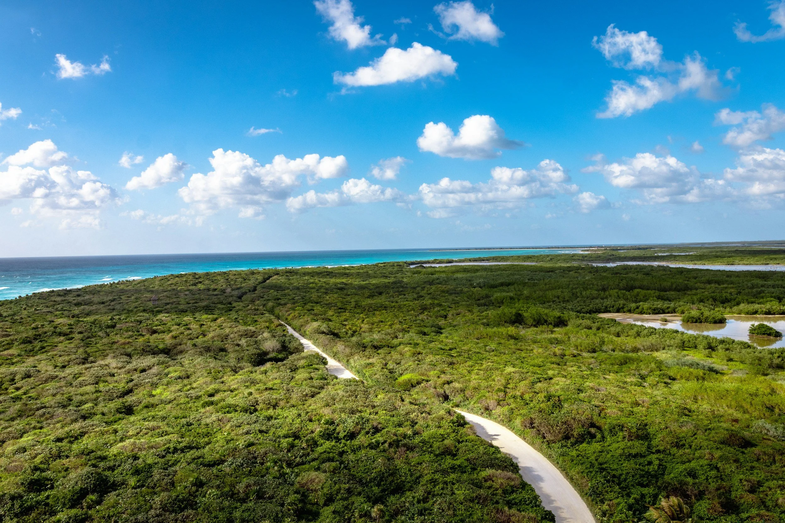
Drones in forestry and agriculture are used for monitoring crop health, managing forest resources, and assessing environmental impacts. They can cover large areas quickly and efficiently.
Benefits:
• Increased Yields: Detects early signs of disease or pest infestation, allowing for timely intervention and improved crop management.
• Resource Management: Optimizes land and water resource allocation, enhancing sustainability and productivity.
• Environmental Protection: Monitors ecosystem health, tracks changes in vegetation, and supports biodiversity conservation efforts.
-
Drones aid government projects by inspecting infrastructure, assisting in urban planning, and conducting environmental monitoring. They provide a cost-effective way to gather data and maintain public assets.
Benefits:
• Enhanced Public Safety: Conducts thorough inspections without disrupting daily activities, improving safety and maintenance.
• Efficient Resource Allocation: Optimizes the use of public funds by providing accurate and actionable data.
• Transparency: Offers visual documentation for public and stakeholder engagement, promoting transparency and accountability.
-
Drones are essential in disaster response and assessment, providing rapid aerial surveys to evaluate damage, assist in search and rescue operations, and monitor recovery efforts.
Benefits:
• Rapid Deployment: Quickly gathers critical information in inaccessible or dangerous areas, aiding swift response efforts.
• Improved Safety: Supports search and rescue missions without risking human lives, enhancing overall safety.
• Accurate Assessments: Delivers detailed damage assessments, helping to prioritize and coordinate effective recovery efforts, ensuring resources are allocated where they are needed most.
Our services
-
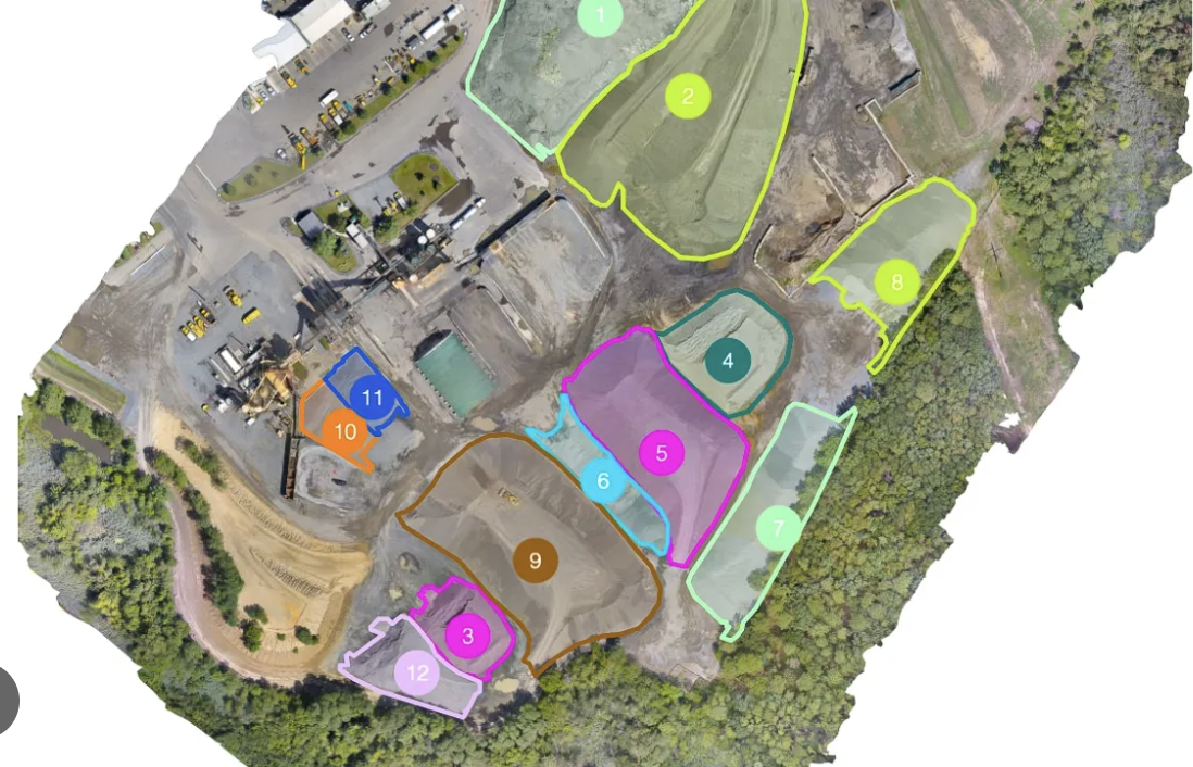
Accurate, fast, and safe stockpile volume measurements and earthworks analysis. We provide you with the critical data you need to manage inventory, track progress, and reduce financial write-offs.
-
Increase Accuracy: Up to 99% accuracy, eliminating guesswork.
Improve Safety: Keep surveyors off unstable piles and away from heavy machinery.
Save Time & Money: Measure an entire site in hours, not days, reducing operational downtime and labor costs.
Better Inventory Management: Make confident business decisions with precise, auditable data.
-
Single Analysis: Starting at $950
Quarterly Monitoring: $850 per visit
What's Included:
High-Resolution Orthomosaic Map
Interactive 3D Site Model
Detailed Volumetric Report (PDF) with cut/fill calculations
Data delivered within 48-72 hours
-
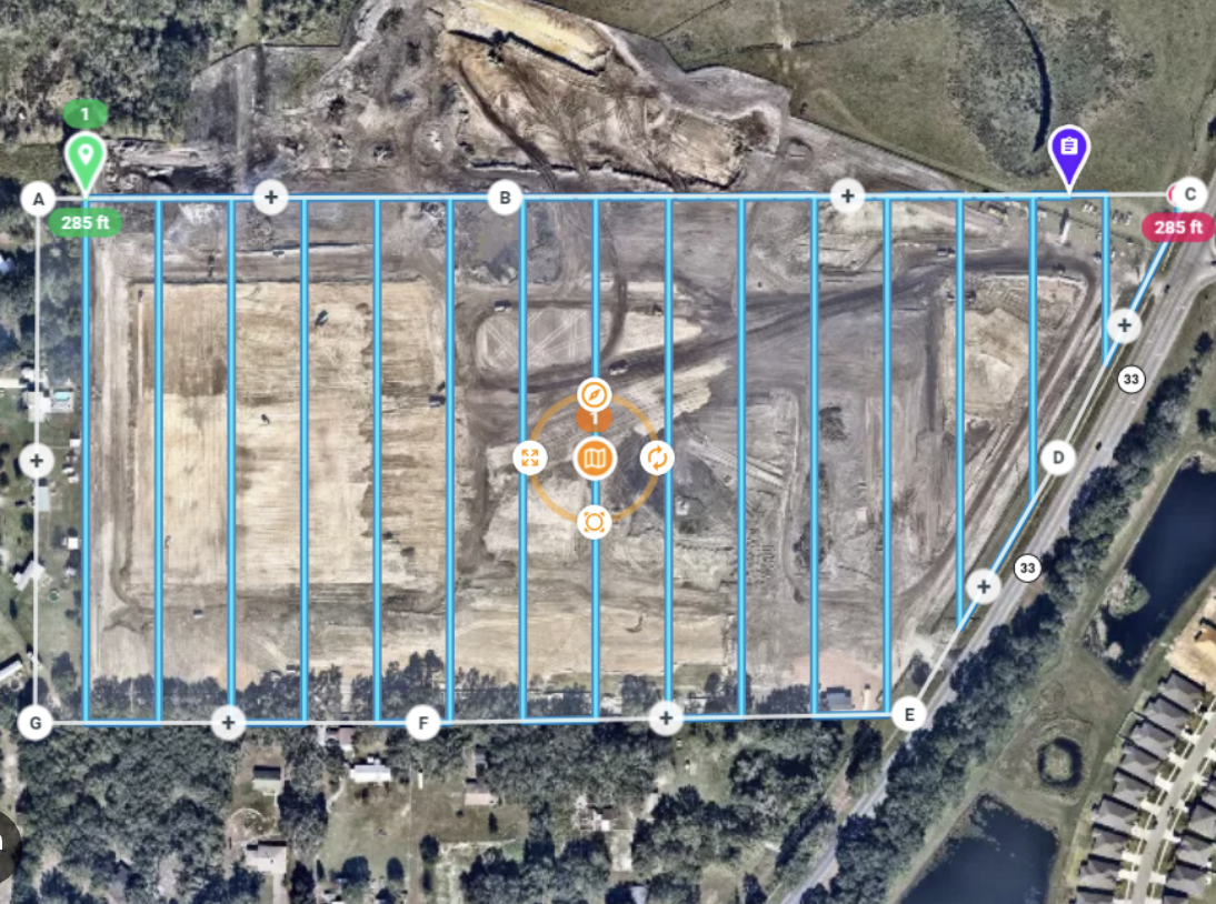
Track your construction project's progress from a new perspective. We provide weekly or monthly visual data and maps to verify work, improve communication with stakeholders, and keep your project on schedule.
-
Enhanced Oversight: Get a complete view of your site that's impossible from the ground.
Clear Stakeholder Reporting: Easily share visual progress reports with clients and investors.
Early Problem Detection: Spot issues like drainage problems or construction errors before they become costly.
-
Monthly Packages: Starting at $800
What's Included:
High-Resolution Orthomosaic Map
Annotated Photos & Video of key areas
Side-by-side comparison overlays from previous visits

-
Go beyond simple visuals with a high-fidelity Digital Twin of your physical asset. We create dimensionally accurate, interactive 3D models that serve as a single source of truth for asset management, maintenance planning, and collaborative project development. It's your facility, on your screen, with centimeter-level detail.
-
Remote Management: Conduct virtual site walk-throughs and plan maintenance from anywhere in the world.
Enhanced Safety: Plan complex tasks and identify hazards in a virtual environment before sending personnel on-site.
Precision Planning: Take highly accurate measurements for retrofitting, equipment placement, or design modifications.
Lifecycle Documentation: Create a perfect "as-built" record of your asset at a specific point in time for historical reference and future planning.
-
Pricing is quoted per project, based on asset size, complexity, and required level of accuracy. Contact us for a detailed consultation.

-
Utilize our advanced drones to conduct safe, fast, and thorough inspections of hard-to-reach assets. We capture high-resolution visual data of roofs, building facades, towers, and other infrastructure, providing you with actionable insights to identify and address potential issues before they become costly problems.
-
Drastically Improve Safety: Eliminate the need for dangerous ladders, lifts, or scaffolding for initial assessments.
Reduce Inspection Time: Inspect a large commercial roof or entire building envelope in hours, not days.
Capture Better Data: Get a complete, objective visual record that can be analyzed and shared with multiple teams.
Proactive Maintenance: Identify minor issues before they lead to major repairs, saving you money in the long run.
Marketing and Promotion: Creates compelling visual content for promotional materials and presentations.
-
Commercial Roof Inspection: Starting at $450 for properties up to 20,000 sq. ft.
Building Facade Inspection: Quoted per project
Post-Hurricane Damage Assessment: Quoted per project
